Import your route
Sync from Strava, Ride With GPS, or Komoot. Or drop in any GPX file. Your route, your planner, your choice.
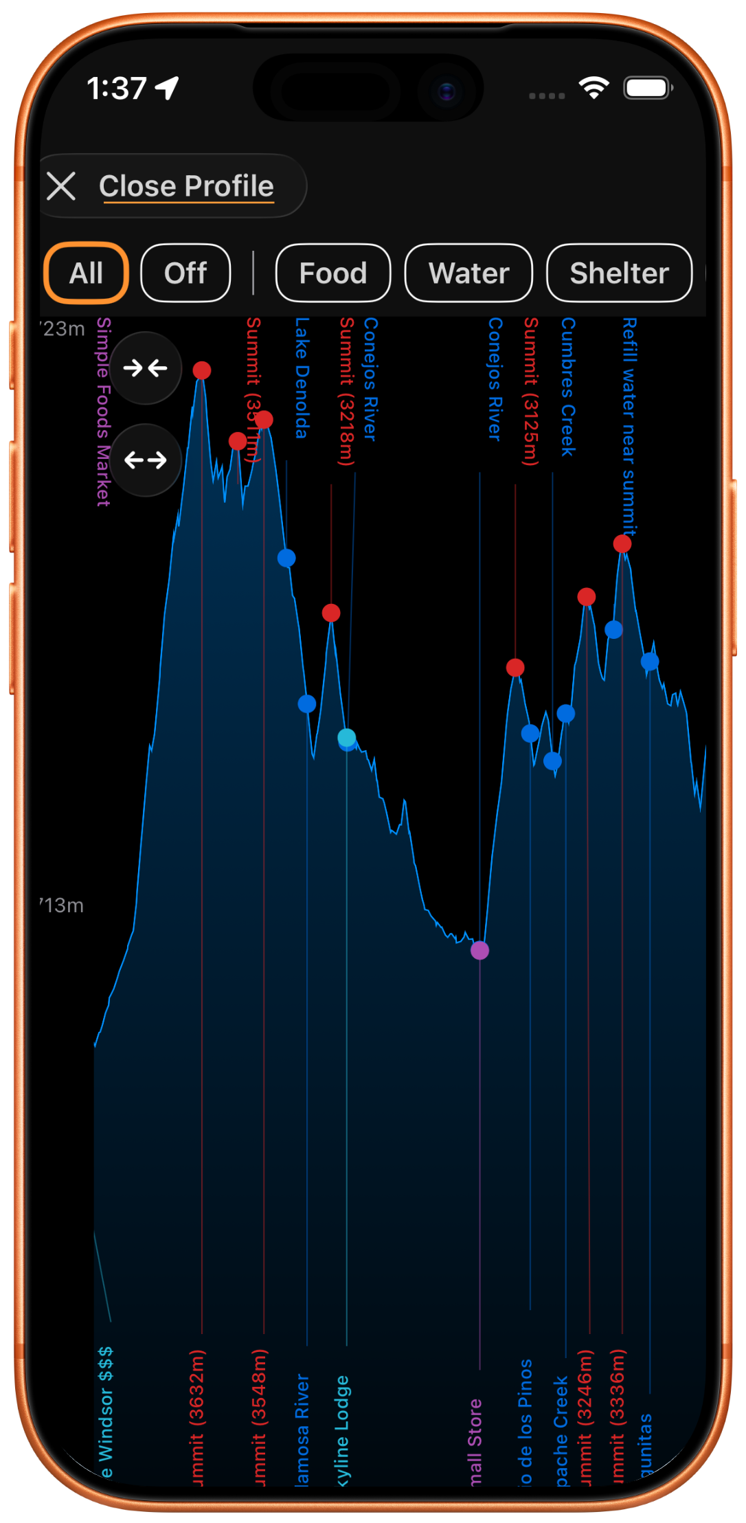
Global weather. Smart ETAs. Critical POI. Repair guides and more. Make fast decisions in the field without burning daylight.

 Spring 2026
You planned the perfect route in Strava or Ride With GPS. But now you are 80 miles in, it is 3pm, and you need to decide: push to the next town or camp at the creek crossing?
Your route planner cannot tell you the overnight temperature at that creek. It does not know if there is a headwind waiting on the ridge. It has no idea whether you will make that town before the store closes at your current pace.
You are making critical decisions with a planning tool...
You need a field tool.
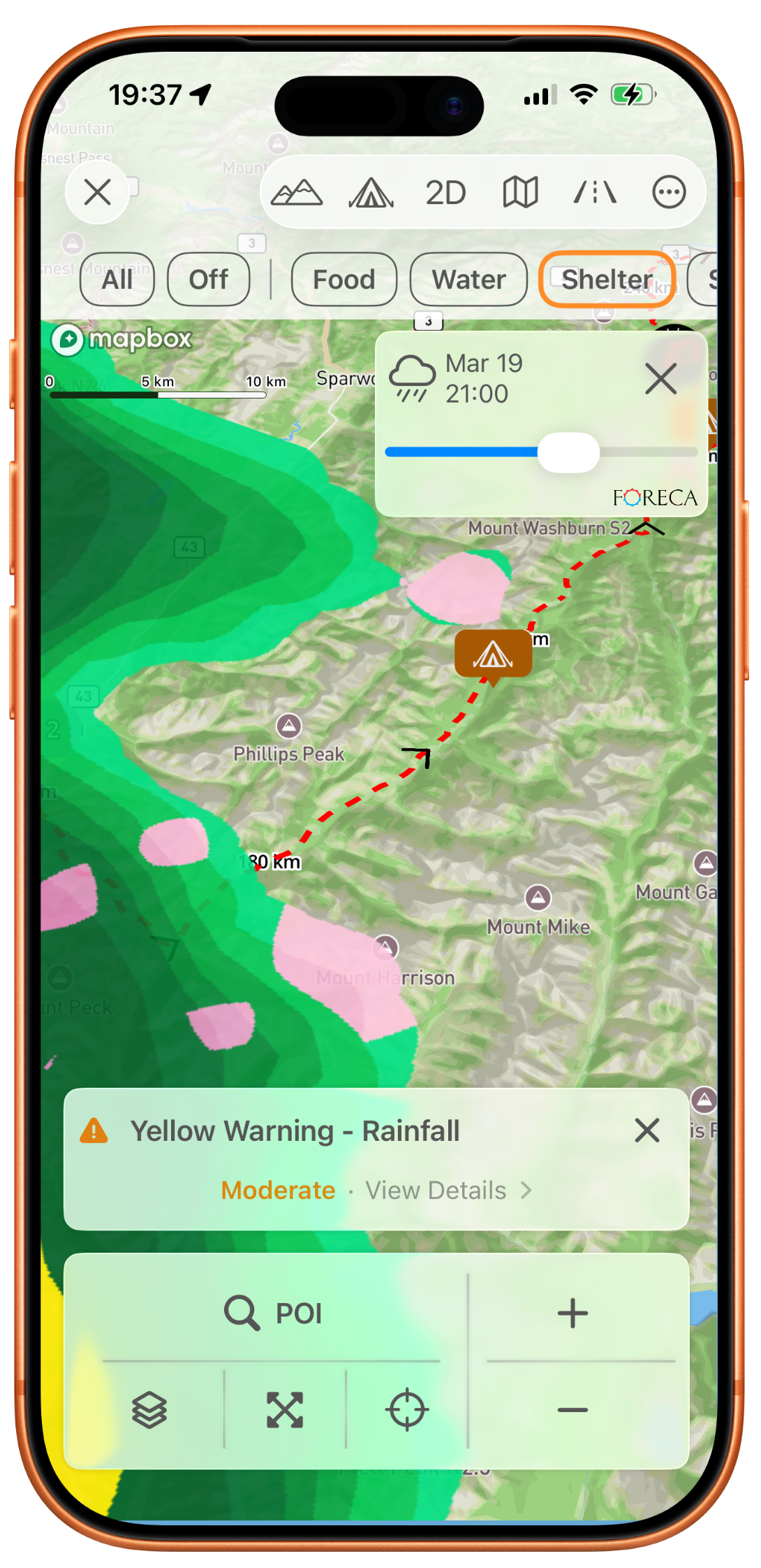
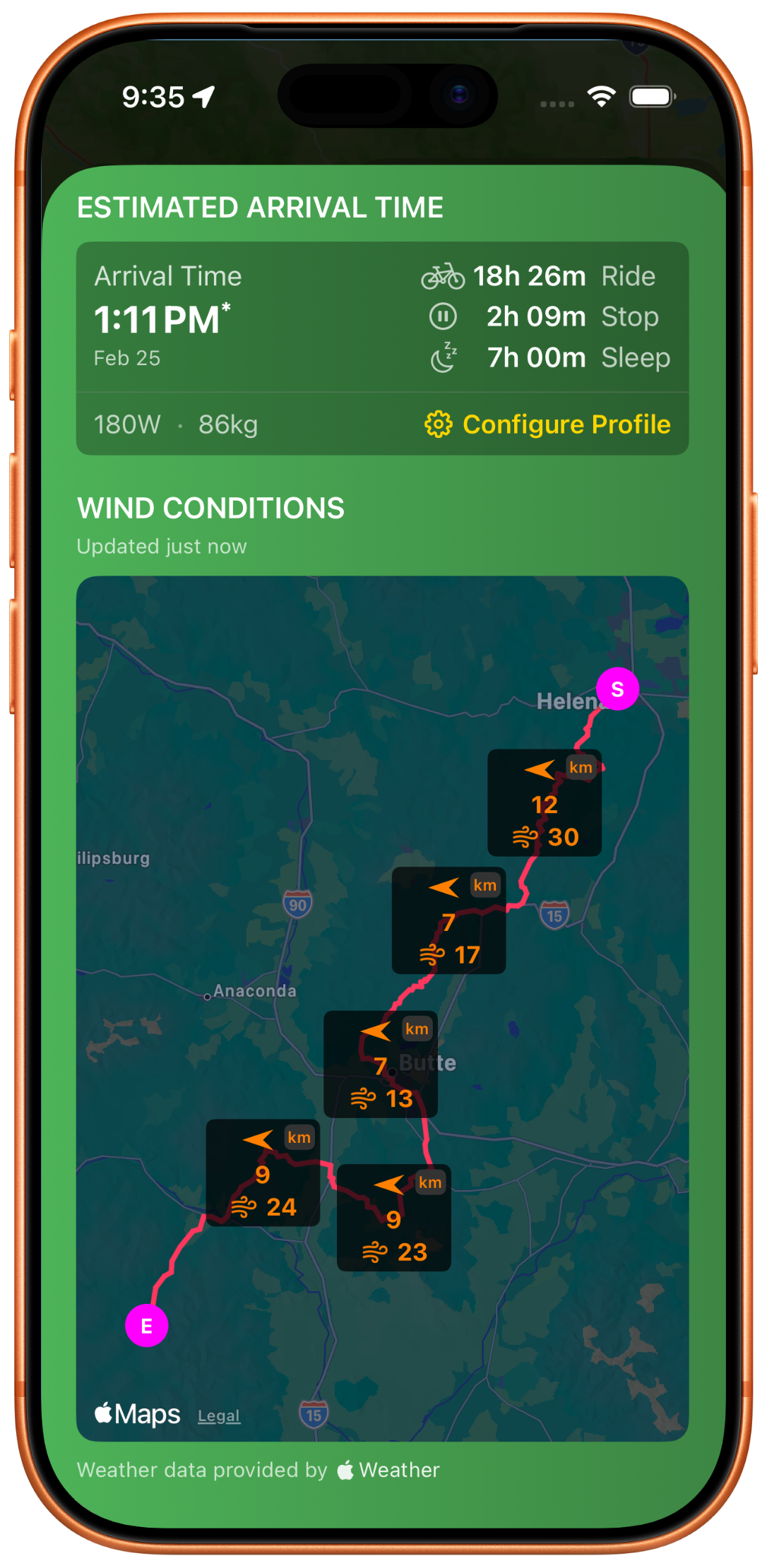
City-level weather is guesswork when you're in the backcountry. BikepackPro gives you hyper-local forecasts for any point on your route - eleven data layers deep. Know what's coming before you climb into it.
Flat-road averages are useless on a loaded bike climbing a mountain pass into a headwind. RideIQ builds a pace model from your actual riding data.
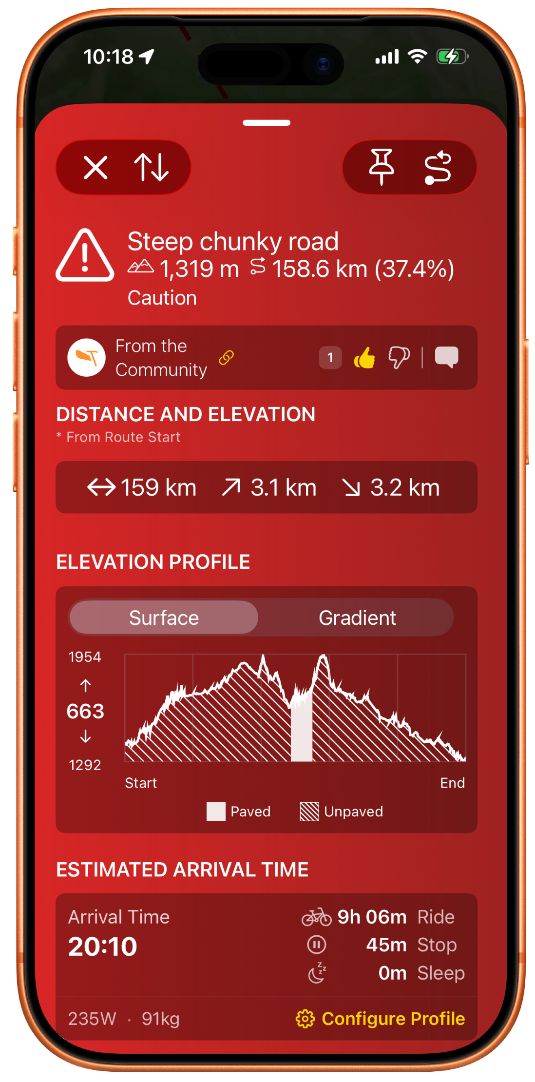
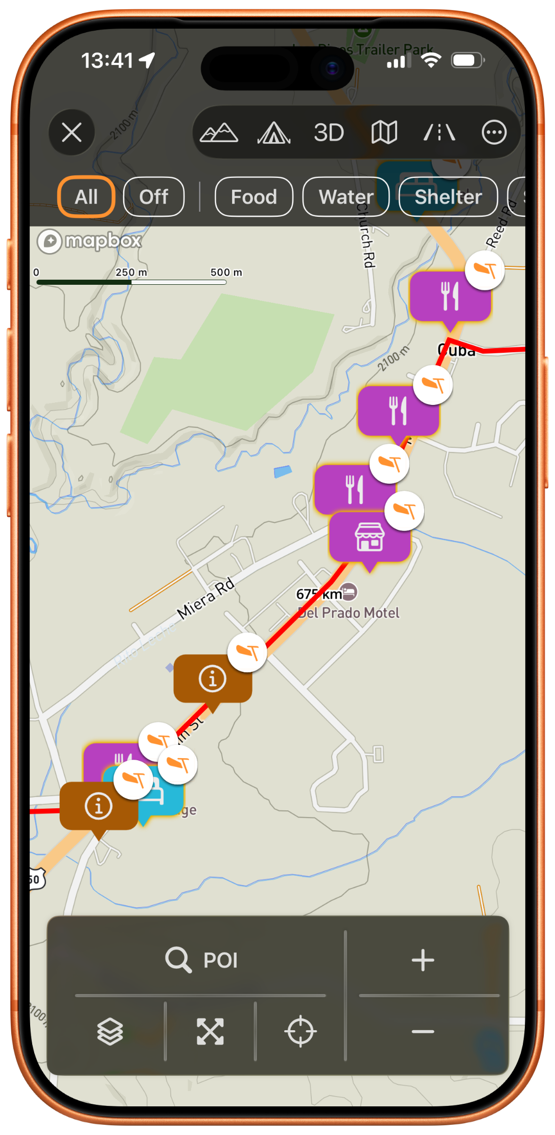
When you need water in 20 miles, you do not want to scroll through a list of coffee shops. Critical POI surfaces exactly what bikepackers need, organized by what matters most.
A GPX file is a line on a map. BikepackPro turns it into a complete field briefing with surface data, elevation analysis, and contextual overlays.
Sync from Strava, Ride With GPS, or Komoot. Or drop in any GPX file. Your route, your planner, your choice.
BikepackPro layers weather, surface data, POI, and personalized ETAs onto your route. Everything updates in real time.
Make confident calls in the field. Where to camp, when to push, whether to reroute. Then put your phone away and ride.
In 2024, I raced the Tour Divide - 2,700 miles of remote dirt from Banff, Alberta to the Mexican border. It is the longest off-pavement cycling route in the world, and it breaks most people who attempt it.
I finished. But the hardest part was not the climbing or the weather. It was the decisions. Every day, dozens of them: Where do I camp tonight? Will I make that town before the store closes? Is that storm going to hit this ridge in two hours or four? Should I push through or hunker down?
I had a route on my GPS. I had a weather app on my phone. But nothing connected them. Nothing could tell me what the weather would be at mile 127 of my route at 7pm tonight. Nothing could give me an ETA that accounted for the 3,000 feet of climbing and the headwind waiting on the other side of the pass.
So I built the tool I wished I had. BikepackPro is not a route planner - it is the intelligence layer that sits between your route and reality. It is the difference between guessing and knowing.
— Matthew
Founder, BikepackPro · Tour Divide finisher
BikepackPro is not a route planner. It is the intelligence layer that sits on top of your favorite one.
Import routes via direct sync or GPX file upload.
Routes, waypoints, maps, navigation - all free. No trial. No time limit.
The one thing that costs real money is weather. Every forecast we pull for your route hits a paid API. Temperature at the pass. Wind at camp. Frost overnight. That data is not free to serve.
Become a BikepackPro Supporter to unlock unlimited weather and help keep the lights on.
Spring 2026
No. BikepackPro is a field intelligence tool. You plan your route in Strava, Ride With GPS, Komoot, or any GPX-compatible planner. BikepackPro then layers on the information you actually need while riding - weather at specific points, adaptive ETAs, and critical POI like water and resupply.
Yes. Download your route and map data before you leave service. Weather and POI data are cached for offline access. When you regain signal, everything syncs and updates automatically.
Most ETA tools use flat averages. RideIQ factors in elevation profile, surface type, wind direction, and your personal pace history. It learns how you ride and gives you ETAs that reflect reality, not theory.
BikepackPro supports direct sync with Strava and Ride With GPS, plus GPX file import from any source - Komoot, Gaia GPS, RideWithGPS, or any other tool that exports GPX.
The free version includes route import, basic map layers, waypoint management, critical POI search, community routes, Camp Weather, and RideIQ. BikepackPro supporters get access to unlimited weather and offline maps.
Download BikepackPro and make your next ride the one where everything just works.
Spring 2026